Tuesday, May 25, 2010

What Do You Mean There's Very Little Virginia Creeper on the Virginia Creeper Trail?

Ladies and Gentlemen, children of all ages, welcome again to another exciting installment of that is just plain strange and weird. Umm wait... sorry wrong life again. Where was I? Oh yeah... So today's entry is all about the Virginia Creeper Trail that runs from White Top, VA to Damascus, VA. It actually goes a bit further than that but the 19 miles from White Top station to Damascus was all Robin and I did yesterday.

So tomorrow is my 35th birthday, and seeing how my birthday is during the week and I didn't take any days off, my darling wife decided she we would take me somewhere fun and special this past weekend. She rented us a nice little compact car to get up there and back and set up reservations with the Creeper Trail Bike Rentals. Initially, she thought it would be neat to rent a tandem bike, however considering we are both control freaks, and it was an off-road trail, upon reaching the bike rental shop she had reconsidered the cuteness of a bicycle built for two and we opted instead for individual steeds to carry us to Damascus. Hmm that somehow sounds like a song that should be wrote, "Riding to Damascus". Maybe I should change this entry's name?

Upon choosing our steeds, settling our affairs with the nice and lovely shopkeeper, and squaring away our gear, we were off on a 2.5 - 3 hour 19 mile adventure. I won't mention the fact that Robin had been diagnosed with a nasty sinus/upper respiratory infection just the day before, but she planned this prior to getting sick, and well she's stubborn and wouldn't take no for an answer. Have I mentioned how much I love that woman? Tough as nails I tell ya.

So our first stop along the trail, there was a few, was at White Top Station. It was 2 miles from the bike rental place to the station.White Top Station was a train depot along the railroad that is now the Virginia Creeper Trail. That's right, the Virginia Creeper Trail is a part of the Rails to Trails program. The trail actually starts at the North Carolina/Virginia line, which is about a half mile further back from the station, but for all intents and purposes, White Top might as well be the beginning. At an elevation of around 3500', White top was the last station in Virginia along the Rail line. The building that stands there now is a replica of the original station. After a brief visit inside, we were ready to continue on our way.

The trail meanders through dense, lush forest land and many Christmas Tree farms. This is likely one of the areas richest commodities. Frasier Firs are grown everywhere in the Highlands of Southwest Virginia, and there are plenty of farms to prove it along the trail. The odd thing we had noticed, well Robin more so than I at this point, was that we didn't see any Virginia Creeper along the trail. You'd think with a name like The Virginia Creeper Trail, the place would be covered in it, but alas there was hardly any at all. As a matter of fact, we've got more on and around our deck, that that trail has.

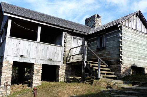
Our next major stop along the way was Green Cove station. This was the last station on the trail between White Top and Damascus. The Green Cove station is still the original building that now serves as a museum and rest stop for all who bike, hike, or ride horse back along the trail. The building contains several items worthy of note from a museum perspective. We highly suggest a stop here and take a look around.

Since time was getting short we were on our way again. There were several little stops here an there to take in the sights and sounds. Halfway down the trail is Taylor's Valley. Here is a nice little town with a cafe for you to  stop in and grab a bite to eat. For us, we didn't have enough time to stop and gallivant. So instead, we opted to stop long enough for a cigarette before heading down the trail. We had to be in Damascus to catch the shuttle back up to White Top by 4:30 and it was already 3:30 or so and we still had 10 miles to go.

Traveling the Virginia Creeper trail, there are several trestles to cross, wild flowers galore to gaze, and cool breezes from the creeks to enjoy. Also, there are several hikers on the trail along the way. It just so happens that the Appalachian Trail joins with the Virginia Creeper in 3 different segments. Additionally there are several cottages along the trail that serve as Bed and Breakfasts.

We eventually made it to Damascus and with a few minutes to spare before the shuttle arrived to carry us back to our starting point to begin our trek home. It was a lovely ride, and we intend on going again at some point in the near future. There is so much to offer in the Damascus and White Top area. There are 3 different parks, miles and miles of trails, stores and more to delight your fancy. Before we headed for home we stopped at a little ice cream parlor to treat ourselves to a job well done.

Just a couple tips before the pics...
- The trail is a bit bumpy at times, so always be alert.
- I highly suggest padded shorts or a gel seat. If you haven't rode a bike in a while, you will have a sore bum the next day. We guarantee it. However, don't let that stop you from one of the most enjoyable bike rides one can take.
- There is no cell phone service on the trail.
- Check out this site for more information: The Virginia Creeper Trail Guide.

Now for the pics.
Enjoy and happy trails,
Tim and Robin

 Our Steeds

Robin and I at White Top Station

White Top Station

Tim Crossing a Trestle

 Tree Hugger Robin

Tree Hugger Tim

Green Cove Station

He's Got a Little Captain in Him

The AT and The Virginia Creeper

Fin

Reward 1

Reward 2

Monday, May 17, 2010

No, not Devil's Haircut by Beck... It was the Devil's Racetrack.

It almost sounds reminiscent of Rob Zombie's "Devil's Rejects" and... well... it might have seemed like it. This weekend we hiked the Devil's Racetrack and let me tell you what, if you think you've found a good trail description of a hike, you'd better try to dig a little more. The write up we found for this one was a far cry from accurate. Here is the link, Devil's Racetrack writeup, I suggest you read that first, then come back here and finish reading for a comparison to the blithe write-up.

So the Devil's Racetrack is 3.3 miles from the trail head. If you read the aforementioned trail description then you now know that this is part of the Cumberland Trail on the Cumberland Segment which leads to Cumberland Gap on the Tennessee, Virginia, and Kentucky border. Behind Cove Lake State Park is the parking area for the trail head. This is located on Bruce Gap road, again if you read the aforementioned trail write-up you would know this as well. For a little extra information you can check out the Cumberland segment of the Cumberland Trail on the Cumberland Trail Conference website.

Sorry for the digression, back to the trail description. From the trail head to the Devil's Racetrack overlook is a total of 3.3 tough miles. The average elevation gain, as best as I could ascertain, is almost 1900'. The terrain is pretty rough due to boulder fields, scree piles, overgrown thickets, etc. There are several switchbacks once you reach the man made waterfalls. This helps to make the ascent to the overlook a bit easier, but still for us experienced hikers, it was definitely challenging.

I have to admit, if you take away the lack of proper trail description, the detraction of I-75 traffic (yes the trail pretty much follows alongside I-75), the heat, and poison ivy galore, then the hike isn't all that bad. There is plenty flora and fauna to set your sites on, as well as geological features galore. The view from atop the 'Racetrack' ain't half bad either.

If you decide to go on this hike, I suggest plenty of water, a few snacks, and something to keep you from getting poison ivy, I pulled my socks up as far as they go. Gaiters would be a good suggestion or pants too. If it's as hot as it was for us then gaiters would be the way to go.

So here are some of the snapshots along the way. You can also view the following site for more pictures of the trail that I wish we had found prior to going. http://www.easttennesseewildflowers.com/gallery/view_album.php?set_albumName=Cumberland-Trail

Happy Trails,
Tim and Robin Bird

The Pictures --


Sunday, May 16, 2010

Lot's of Hiking Already this Year

Well hello folks, and welcome to another edition of the great outdoors with your host Robin and Tim. It's been sometime since our last post and we would just like to apologize for that. For you see, we had some issues with funding and our sponsors... erm wait a minute... sorry... just ignore that...

Okay, so, right yes, this year has been quite the year so far. We've made it to May and already several hikes have been accomplished. We decided to keep a log of our hikes this year, and for the years to come, just to keep track of the miles we have hiked. To date, we have over 30 miles logged and our newest fancy spot for hiking, the area we seem to be focusing on, is the Cumberland's in Tennessee. From Cumberland Gap at the TN, KY, and VA border, all the way down to Spring City so far and even a little farther south to Dayton, TN.

We have been to several different and each uniquely beautiful water falls (Ozone Falls in Crab Orchard, Stinging Fork Falls in Spring City, Piney Falls in Spring city, and a couple others). We hiked to a cave (Windless Cave to be exact) and to White Rocks, (a huge rock outcropping that you can't miss). There are a few other trails that we've been on, but of those, the most memorable so far has been the backpacking trip Robin and I took up Mount LeConte in the Great Smoky Mountains to stay the night at LeConte Lodge for our anniversary.

For the hike up to LeConte Lodge, we took the Alum Cave Bluff trail. This is a 5.5 mile trail with an average elevation gain of 2,560'. It was an absolutely beautiful day to hike up a mountain even if we were lugging 15 or 20 pound packs. It took us roughly 3.5 hours to make it to the lodge, which included a rest stop at Alum Cave, and plenty of photo ops.

Staying at the lodge was absolutely wonderful and the charge isn't that much considering. There's plenty to do on top of the mountain, which includes but is not limited to, watching the sunset from the Cliff Tops trail, watching the sunrise from Myrtle's Point, or congregating with other visitors to the lodge who share the same love of nature. Staying at the lodge is a pure disconnect from our electronic world. It's refreshing to get away from the hustle and bustle of the everyday rat race.

Upon reaching the top of the mountain and getting to the lodge, we were escorted around on a brief tour. The dining hall, the facilities, our cabin, etc. We had a couple of hours to kill before supper would be served, so we sat around took in the sights, drank cups of coffee and cocoa, and rested a bit from the strenuous hike. Supper was served and we enjoyed beef w/gravy, mashed taters, soup, green beans, cinnamon apples and more. You can even drink wine if you've paid for it. After supper, the office has a host of games, puzzles, books and more to pass the time. We played checkers and chess until it was time for bed. It would be an early morning especially knowing that we would have to hike down the mountain in rain.

It was apparent that in our lodge, we had some visitors that kept Robin awake half the night. Luckily they were never able to get into our room even though they tried. Tim wouldn't have known anything about it as I slept soundly in the double bunk. That morning we awoke to a ominous morning sky, filled with dark clouds that told the story of approaching rain. Soon enough it was time for breakfast. A nice hearty meal to fuel up on prior to the hike down.We ate pancakes, eggs, grits, Canadian bacon, and more. We again enjoyed the company of other guests at the lodge while we feasted.

It wasn't long after breakfast that we had our packs ready to go and we were headed down the mountain. It was about 30 minutes worth of dry hiking before the sky decided to open up. Luckily it was a slow soaking rain, and much to our surprise, it wasn't as tough of a hike down as we initially thought it would be. By the end of it however, we were thoroughly soaked. Thankfully our pack's rain flies kept most everything inside dry as a bone. We reached the car and gave our lodge mates a ride to their vehicle which they parked at Newfound Gap. After that we headed home with the heater blowing full blast.

Well that's our story and we are sticking to it. Did we mention that LeConte Lodge offers day hiker services? Yes a day hike to the lodge can be just as rewarding as an over-night stay. We plan to one day return even if just for a day. There are plenty other trails to take up there and we'd like to say that we've hiked them all.

Until next time, enjoy the photos of our various hikes so far.

Peace,
Tim and Robin.

Black Mountain - Windless Cave

Stinging Fork Falls

Ozone Falls

Piney Falls

White Rocks
 

 Alum Cave Bluff to LeConte Lodge